Understanding earthquake hazard
Earthquakes occur due to the accumulation of strain that builds up within Earth’s lithosphere: in a region that is virtually impossible for us to see, and over time scales that can be difficult for us to monitor. The speed of the motions that end up creating earthquakes is roughly comparable to the speed at which fingernails grow—it’s a slow process! This makes it hard to figure out exactly where or when an earthquake might occur.
There are a few methods used for earthquake forecasting though—and note the use of the specific term ‘forecasting’. It is never called earthquake ‘prediction’ as this word implies a level of accuracy that is simply not yet achievable.
The best method currently available to scientists and planners regarding earthquake forecasting is the record of seismic events that have occurred in an area in the past. Looking at the frequency of events of particular magnitude over time, scientists can calculate the statistical probability of similar events occurring within a certain timeframe in the future.
Along with these statistical calculations, a lot of work has been done examining the geological record of earthquake-prone regions of the crust to understand how many earthquake events have occurred, when they occurred and what size they were. Looking at the rock record in this way provides scientists with a much longer-term record to complement limited historical observations.
Using these insights from the geological record, scientists can then make assessments of modern day environments and how their geological setting will influence the likelihood and potential impacts of earthquakes that may occur there.
Models of potential future events and their impacts are also constructed to create possible scenarios of how an earthquake hazard may pan out. These are used to inform emergency planning decisions: an essential part of community preparedness is ensuring that everyone is aware of potential hazards and has an appropriate response plan for the event of an earthquake.
This modelling work projecting earthquake scenarios is combined with extensive surveys of the damage caused by past events and assessments of how buildings responded to inform the development of building standards. A comprehensive building code has been in place in Australia since 1995 but much of our infrastructure pre-dates this, so efforts are also concentrated on developing ways to retro-fit existing buildings.

If we know that earthquakes are caused by the release of strain (deformation of the rocks) that builds up when tectonic plates move against each other, then why can’t we just monitor the plates’ movements and figure out how much strain is building up and when it is going to reach that critical release point?
Scientists are trying—but there is still much work to be done.
Monitoring Earth's crust
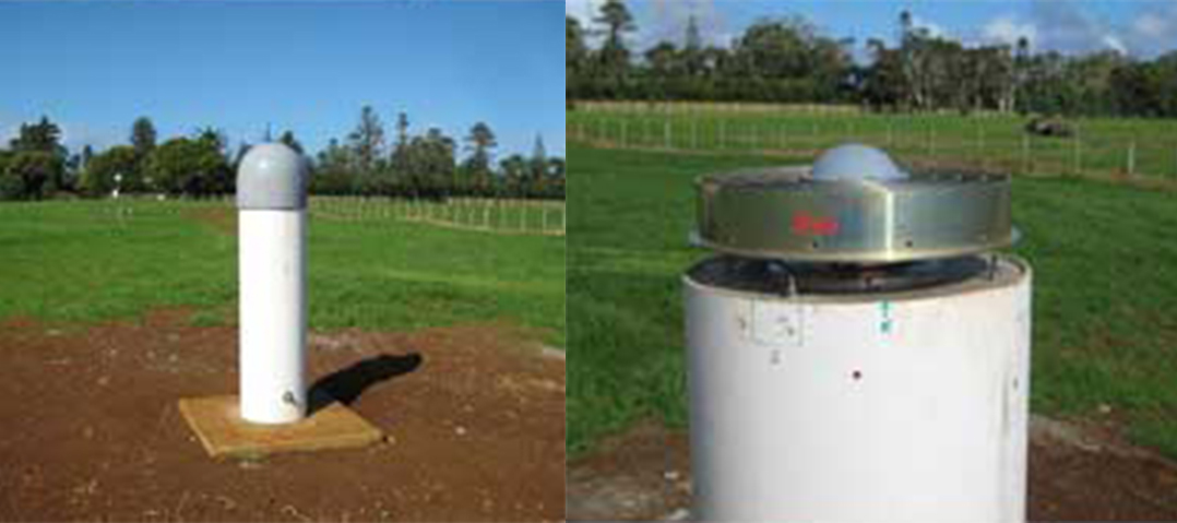
As part of the AuScope program, more than 100 continuously-operating satellite sensors have been put in place all over mainland Australia, as well as on several of Australia’s island territories. The sensors track the global navigation satellite systems (GNSS), including the United States GPS satellites, the Russian GLONAS system, the Chinese Beidou system, Japan’s QZSS and the European Union’s Galileo system. This tracking data enables scientists to determine highly accurate locations for the sensors and how these locations change over time (as the tectonic plates move). The data also supports the International GNSS Service and a wide range of other applications.
The sensors themselves are unassuming—a simple-looking device atop a short concrete post that is attached directly to the bedrock. Yet despite their modest appearance, they are collectively pulling together some incredible data. The continual stream of data from the sensors means scientists can track the movements of the Australian continental plate with millimetre accuracy, watching it in real-time as it drifts inexorably northward at a rate of around seven centimetres per year.

How does this relate to earthquakes? By comparing the rate of movement of each individual sensor compared to the other sensors, scientists can see which areas of the plate are moving faster than others. By picking up ‘distortions’ in the plate’s movements, they can use this to figure out where strain might be accumulating. Monitoring these factors can provide clues as to where an earthquake might be likely to occur. The actual failure to result in an earthquake will depend on how much strain the local crust can accommodate. Nevertheless, this sort of baseline data is essential to putting together the entire picture of how our planet works.
This technique has worked well for monitoring active plate boundary areas, but as our Australian plate is moving (and deforming) so slowly, it will take quite a while before we can gain significant insights into our crust. The system has been up and running for around eight years, yet it will take decades for patterns in the data to emerge that allow improved forecasting.
Here’s hoping that as we learn more about the movements of Earth's crust, we can build a more accurate picture of when, and where, earthquakes might occur in the future.


