Protecting people from tsunami
Expert reviewers

Essentials
- A tsunami is a series of waves that result from the displacement of large amounts of water.
- Most tsunami are caused by undersea earthquakes.
- Although we can’t predict tsunami-causing events, there are systems to assess the risk and severity of tsunami that may occur after events have been detected.
The word 'tsunami' is Japanese, meaning 'harbour waves'. The Japanese know a lot about the destructive nature of these giant waves, having suffered from their effects for centuries. But the term 'harbour wave' is misleading, since tsunami don't just occur in harbours. Nor are they ‘tidal waves’—although the height of the tide may affect the strength of their impact, they are not controlled nor caused by tidal movements.
If we want a descriptive name for them, although it’s not very catchy, we could call them ‘displacement waves’, as they are caused when some sort of land movement causes a large amount of water to be displaced. Tsunami can be caused by undersea landslides, or the slumping of large amounts of rock or sediment into the sea. Volcanic eruptions, explosions and meteorite impacts can also cause tsunami. A meteorite 5–6 kilometres in diameter landing in the middle of the Atlantic Ocean would apparently create a tsunami that would swamp the entire upper east coast of the USA. No need for immediate alarm though—Earth is likely to be struck by an asteroid of that size every 26 million years or so.
What is a subduction zone?
By far the most common cause of tsunami is undersea earthquakes, and usually it’s earthquakes associated with subduction zones. When an earthquake occurs, big chunks of Earth’s crust are displaced. If these massive chunks of Earth’s crust are under the ocean, the movement causes the water lying above it to also shift, shunting huge amounts of water away from the source of the earthquake in a series of huge waves.
A subduction zone occurs when two tectonic plates meet and one plate ‘slides’ beneath the other. This happens because Earth has two main types of crust—continental crust and oceanic crust. They are made of different minerals and oceanic crust is denser than continental crust. When a plate carrying oceanic crust collides with a plate carrying continental crust, the denser oceanic crust is forced below the continental crust. Around 90 per cent of all earthquakes worldwide occur along the subduction zones around the Pacific Ocean—the Pacific ‘Rim of Fire’. The movement of tectonic plates in this process can cause very large displacements in the ocean floor, which is why they so are so often accompanied by tsunami.
The energy within a tsunami
The earthquake or other disturbance that causes a tsunami can impart a great deal of energy into the wave. The energy (the capacity to do work) in any ocean wave is proportional the square of the wave height (the distance between the trough and the crest). A wave’s power (the rate at which work is done) is determined by the wave length—the distance between two crests—and the wave height.
Most ocean swell waves have a wave length of around 30–40 kilometres. A high-energy tsunami in the deep ocean may have a height of less than a metre but a wave length of hundreds of kilometres—in effect, its energy is spread out across the ocean. The long wave length of tsunami means that they lose energy quite slowly, so they can travel vast distances and still wreak havoc when they hit a coastline.
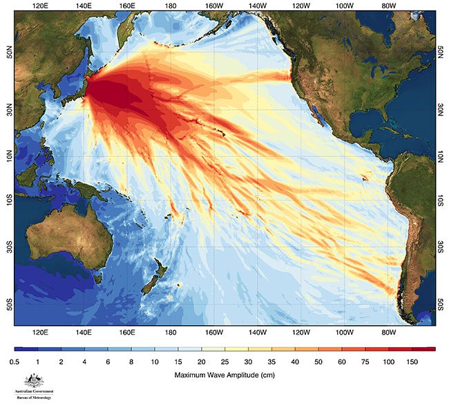
For example, an off-shore earthquake near Chile in 1960 sent waves speeding in all directions across the Pacific Ocean. The height of the waves was no more than a metre or so—which means they’re not easily noticeable to the naked eye. The waves travelled extremely fast and, just 22 hours later, a wave 6 metres high struck the coast of Japan on the other side of the ocean, killing around 200 people. This tsunami was felt in Australia too, with wave heights up to 84 centimetres recorded in Sydney Harbour. The tsunami continued to reverberate around the Pacific for days, causing damage whenever it struck land.
So what caused the tsunami, which had a height of one metre out in the deep ocean, to be six metres high when it struck land?
Well, as water becomes shallower, the wave length and wave velocity both decrease, but the wave doesn’t lose any of its energy. To satisfy the relationship between wave length, wave height and energy, this means that the wave height must increase. So, as waves approach land from the deep ocean, their height increases.
The impacts of tsunami
Many tsunami don't break as they hit land. They simply surge, flooding low-lying areas and rebounding off cliffs or hills, often causing as much or more damage as they recede back into the ocean. What’s more, remembering that tsunami are a series of waves, there’s not just one hit. Often there will be wave after wave of tsunami, resulting in a continued destructive sweep that occurs over a period of up to 24 hours, and sometimes even longer. Tsunami have been known to reach several kilometres inland, with the power to carry cars or ships along with them.
Along with the obvious risk to human lives, coastal inundation and flooding can occur, with significant damage to buildings and other infrastructure. There can be serious consequences if this infrastructure happens to be, say, a nuclear power plant. The Tōhoku earthquake that occurred off the coast of Japan in 2011 led to a tsunami that hit the eastern coast of the country where the Fukushima Daiichi nuclear power plant is located. The plant was badly damaged, causing a Level 7 meltdown. Radioactive material was spilled into the surrounding environment—a serious nuclear disaster. Some tsunami may not have a significant impact on coastal areas, but can still make their presence felt in the form of dangerous rips and currents offshore. Tsunami can circle the globe more than once, with their effects lasting for days.
THE 2004 INDIAN OCEAN TSUNAMI
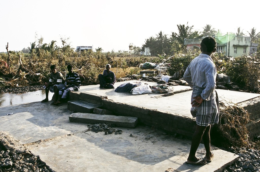
The tsunami that struck coastal regions of the Indian Ocean on 26 December 2004 killed more than 289,000 people and left many more injured or without homes. The surge of sea water that caused the destruction was the result of the largest earthquake in the world for 40 years. The main earthquake was magnitude 9.1 and was followed by a series of aftershocks of between 5.7 and 7.3 in intensity. Less severe earthquakes are often measured in the region.
The earthquake was caused by the movement of the India plate and the Eurasia plate. The India plate is moving north at an average of 6 centimetres per year and is being forced under the continental Burma plate. On 26 December, the plates suddenly shifted 15 metres over a length of 1,200 kilometres. The amount of vertical displacement of the crust varied (some parts were uplifted, other parts subsided), but was generally around 4–5 metres. The epicentre of the earthquake was off the west coast of northern Sumatra, Indonesia. The shift in the plates on the ocean floor created a tsunami, which spread across the Indian Ocean and caused devastation in coastal settlements in Asia and Africa.
Unfortunately, at that time, there was no early warning system for tsunami in countries surrounding the Indian Ocean as there is in the Pacific. The earthquake was detected by many monitoring stations, but there were no tsunami detection buoys in place to pick up the signs of an impending/incoming tsunami. And while there was some information regarding tide heights being measured, this data was not available in real time for the type of analysis and assessment necessary to issue adequate warnings.
In response to the event, the UNESCO Intergovernmental Oceanographic Commission established the Indian Ocean Warning and Mitigation System. At first the Japan Meteorological Agency and the Pacific Tsunami Warning Centre provided information, and since 2011 three tsunami service providers have provided tsunami threat information to the 28 nations of the Indian Ocean region.
THE TŌHOKU EARTHQUAKE AND TSUNAMI
Off the east coast of Japan, the Pacific plate is subducting beneath the Eurasian plate. On 11 March, 2011, a magnitude 9.1 earthquake was triggered by the sudden rapid movement within this subduction zone. The quake shook the ground for 6 minutes. Its epicentre was 72 kilometres offshore from the eastern coast of Japan, and 30 kilometres underground. It took less than an hour for the first tsunami wave to hit. This earthquake was so powerful it shifted the island of Honshu to the east by around two and a half metres, dropped the coastline of Honshu by around half a metre and even affected the axis of Earth’s rotation.
The water surged as far as 10 kilometres inland in Sendai, and reached heights of 39 metres above sea level at Miyako city. Flooding covered an area of around 560 square kilometres. More than 15,000 people were killed.
We felt the effects of this tsunami in Australia, too, but with nowhere near the force that hit Japan. Unusually strong currents were reported in Sydney Harbour and Port Kembla, and some swimmers were swept into the lagoon at the coastal town of Merimbula in southern New South Wales. Around 18 hours after the earthquake, waves of around 30 centimetres high hit the coast of Antarctica.
Predicting and preparing for tsunami
There is a huge amount of variability in the actual events that can cause tsunami—earthquakes can have vastly different magnitudes and very different displacement regimes. The concentration of the quake’s energy will impact the way the seismic waves propagate through the surrounding rock, and the rock types themselves can also affect the way seismic waves travel.
Generally, only earthquakes with a magnitude greater than 6.5 will generate tsunami, and the most destructive tsunami are generated from earthquakes that occur in relatively shallow regions of the crust.
While forecasting future tsunami-generating events is basically not possible beyond statistical predictions based on records of past events, a lot of work has gone into figuring out how tsunami behave and what their impacts may be.
Factors like the shape of the sea-bed, the water depth and the coastal landscape all affect the way tsunami travel and impact on coastal areas. Coastal harbours and headlands can cause the waves to bounce back into each other and change their direction—tsunami (and other waves) can 'bend' around islands, eventually engulfing the coast on what was supposedly the protected side. Other complicating factors include the effect of backwash from one wave on the waves that follow, and the exact nature of the disturbance that generated the tsunami in the first place.
A tsunami can travel at the speed of a commercial jet—around 640–960 kilometres per hour. This is pretty fast, but it does give people some time to respond and prepare if adequate warnings promptly follow the tsunami-generating event. This obviously depends on how far away people are from the earthquake’s epicentre—in mainland Australia we’re likely to be far enough away from the action to have adequate time, but other nations situated closer to the Pacific Rim of Fire may have very little time to respond.
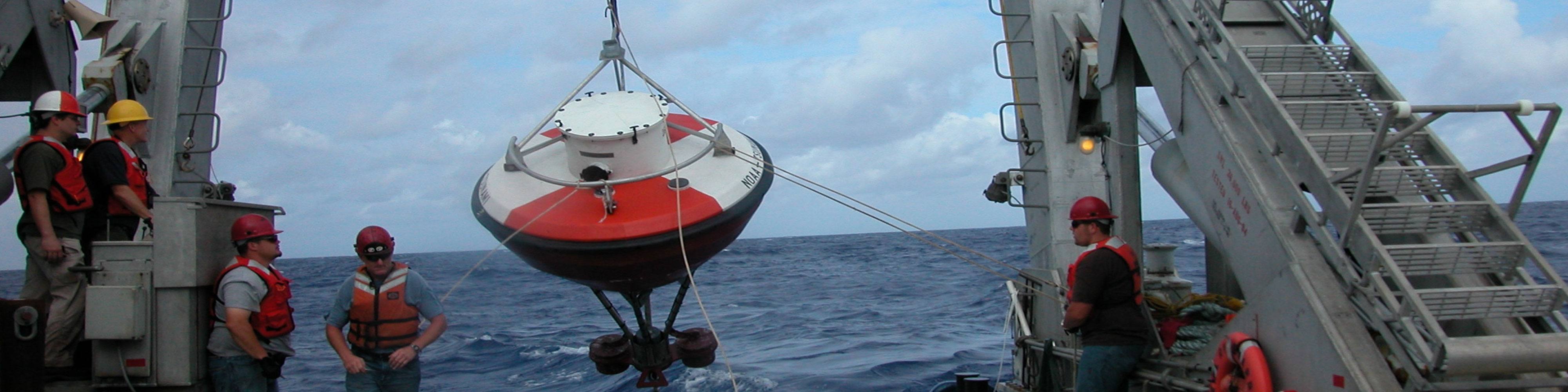
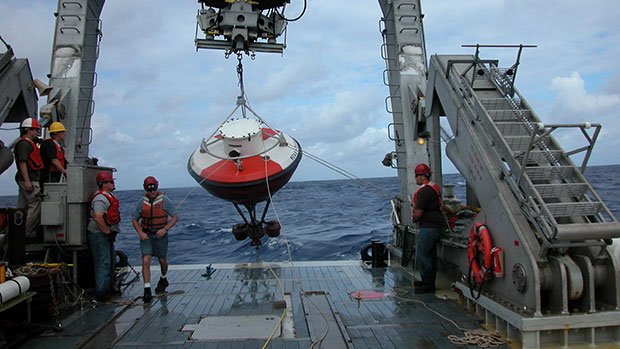
Along with all the seismic monitors that have been deployed on land are buoys positioned in the ocean that detect changes in pressure that result from the movement of a large amount of water. These are used to detect the presence of tsunami and track the direction and speed of their movement.
And it’s not just being able to predict how the impacts of a tsunami may pan out—‘peacetime’ preparedness is just as important. Having appropriate procedures in place to quickly assess the risk of a tsunami, issue effective and clear warnings and manage evacuation procedures are essential. Ensuring residents who live in high-risk areas for tsunami are educated and aware of both the risks and appropriate actions to take in the event of a tsunami is also important.
The Australian Bureau of Meteorology has modelled almost two thousand tsunami to create a set of ‘canned’ scenarios that describe the likely impact of tsunami generated by earthquakes of various magnitudes and locations. This ‘library’ of possible events serves as a guide for emergency managers when it comes to preparing for tsunami events and issuing warnings.
We must also remember that even with the best possible information and preparedness strategies, nature can still be unpredictable and surprise us. Around 100 tsunami evacuation centres in Sendai were affected by the tsunami during the Tōhoku event in 2011, highlighting the importance of continuous risk-assessment.
A thing to remember is that all warning systems and preparation procedures depend on accurate and timely detection of the event that causes the tsunami. If the tsunami is caused by something other than an earthquake, say, an underwater landslide, there will most likely be no warning (unless there is an appropriate array of tsunami detection buoys in the vicinity).
The Joint Australian Tsunami Warning Centre
A number of Australian government agencies—the Bureau of Meteorology, Geoscience Australia and the Attorney General’s Department—all work together to support the Joint Australian Tsunami Warning Centre (JATWC).
Geoscience Australia is responsible for overseeing a series of seismic monitors in the Indian, Pacific and Southern oceans that provide near-instantaneous information regarding earthquake events. An automated system reviews events to determine the likelihood that a tsunami will result. An expert seismologist then makes a final determination and passes on relevant information to the Bureau of Meteorology, within 15 minutes of the earthquake event.
The Bureau of Meteorology manages an array of coastal sea level gauges and oceanic tsunami detection buoys and uses the information from these, along with the seismic information from Geoscience Australia, to select the appropriate pre-computed scenario, assess the ultimate tsunami risk and potential severity and then issues any appropriate warnings. The JATWC continues to monitor the event to see if it unfolds according to the prediction, and updates warnings and advice as necessary.
The JATWC also participates in international efforts to provide warning of potential tsunami in the Indian Ocean, contributing information to the Indian Ocean Tsunami Warning and Mitigation System. The national authority of each country is then responsible for issuing tsunami warnings to their citizens.
While tsunami events are rare, they can be devastating. However, through a combination of rigorous science, consistent and reliable monitoring of our Earth and oceans, and appropriate preparation and warning procedures, we are working towards a better understanding of these potentially deadly events to protect our communities and keep people safe.